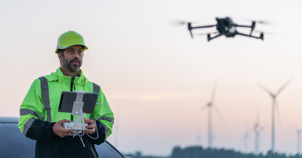
In today’s fast-evolving utility landscape, drone technology—or Unmanned Aerial Vehicles (UAVs)—is no longer a futuristic concept but a transformative tool reshaping how we manage critical infrastructure across the United States. For utility professionals, engineers, and decision-makers, drones are proving to be indispensable, offering a safer, faster, and more cost-effective alternative to traditional methods like ground crews or manned helicopters. What was once a labor-intensive process involving climbing poles or chartering flights is now being streamlined by aerial systems equipped with cutting-edge sensors.
Let’s explore how drones are redefining utility surveying and line patrol operations—from power line inspections to vegetation management—while unpacking the tangible benefits, real-world challenges, and forward-looking potential of this technology. For those tasked with keeping the lights on and the grid humming, understanding drones isn’t just valuable—it’s a strategic necessity.
Understanding Drone Technology in the Utility Context
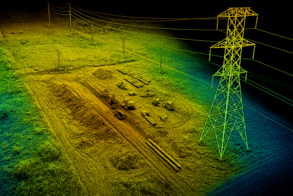
At their core, drones are remotely operated or autonomous aircraft designed to tackle tasks that once demanded significant human effort and risk. In the utility sector, they’re outfitted with advanced tools like RGB cameras for crisp imagery, LiDAR for precise 3D mapping, and thermal imaging to spot heat anomalies in equipment. These capabilities deliver detailed, actionable data from vantage points that were previously hard to reach.
Utility operations typically rely on two types of drones:
- Multi-rotor drones: Perfect for close-up work, these nimble systems hover and maneuver with precision, making them ideal for inspecting transmission towers or substation components.
- Fixed-wing drones: Built for stamina, these models cover vast stretches quickly, excelling at surveying utility corridors or mapping terrain for infrastructure planning.
This versatility lets utility teams customize drone deployment to their specific needs—whether it’s a detailed inspection of a single asset or a broad sweep of a multi-mile right-of-way.
Real-World Applications Driving Change
Drones are already making their mark across a range of utility tasks, turning once-tedious processes into efficient, data-driven workflows. Here’s where they’re delivering impact:
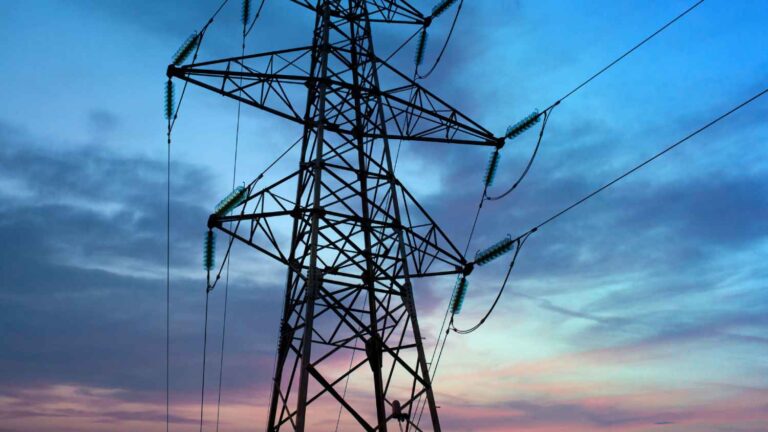
- Power Line Inspections: Utility companies now use drones to scrutinize high-voltage transmission and distribution lines, capturing high-res images and thermal data to pinpoint issues like insulator cracks, conductor wear, or overheating joints. No more sending workers up poles or into hazardous zones—drones handle it from the air.
- Topographical Mapping: With LiDAR and photogrammetry, drones generate accurate 3D models of landscapes, supporting site planning, infrastructure design, and construction oversight. This precision ensures projects start with a clear, reliable picture of the terrain.
- Vegetation Management: Overgrown trees and brush near power lines are a top outage culprit. Drones with multispectral cameras survey these areas, mapping encroachment risks and guiding targeted trimming efforts to prevent disruptions.
These applications don’t just save time—they elevate accuracy. A task like inspecting a 10-mile transmission line, which might have taken days with boots on the ground, can now wrap up in hours, freeing teams to focus on analysis and execution.
The Payoff: Why Drones Matter
The shift to drone-based operations delivers clear, practical advantages that tackle some of the utility sector’s toughest pain points:
- Safety First: Drones eliminate the need for workers to climb poles, trek through rough terrain, or work near live lines. In an industry where safety is non-negotiable, this reduction in risk is a game-changer.
- Speed and Agility: A drone can survey miles of line or a sprawling substation in a single flight, delivering real-time data that accelerates decision-making. What used to drag on for days now takes a fraction of the time.
- Cost Efficiency: Forget the fuel, heavy equipment, or helicopter rentals—drones cut operational costs without skimping on quality. The savings pile up fast, especially for routine patrols or large-scale surveys.
Across the country, utility providers are seeing these benefits in action: safer crews, faster turnarounds, and leaner budgets. It’s not just about doing things better—it’s about doing them smarter.
Navigating the Challenges
For all their promise, drones aren’t a plug-and-play solution. Utility professionals face a few hurdles to unlock their full potential:
- Regulatory Hurdles: The FAA’s rules—think line-of-sight mandates and airspace restrictions—can complicate operations, especially in remote or urban settings. Staying compliant takes planning and expertise.
- Weather Constraints: Drones don’t love high winds, rain, or extreme cold. These limitations can disrupt schedules, so teams need contingency plans to keep workflows on track.
- Data Overload: From detailed images to intricate 3D models, drones churn out massive datasets. Without robust systems to store, process, and analyze this information, it’s easy to drown in the details.
The good news? These challenges aren’t dealbreakers. Weather-resistant designs, automated data tools, and evolving regulations are already smoothing the path forward.
What’s Next: The Future of Drones in Utilities
Looking ahead, drones are set to become even more integral to utility operations, driven by innovations that push the boundaries of what’s possible:
- AI and Machine Learning: Pairing drones with artificial intelligence could enable autonomous flights and real-time analysis—think a drone that not only inspects a line but flags maintenance priorities on its own.
- Next-Gen Sensors: Advances like hyperspectral imaging could spot equipment wear before it’s visible, paving the way for predictive maintenance that catches issues early.
- Beyond Line of Sight (BLOS): As FAA rules loosen, BLOS operations could let drones roam further, tackling remote infrastructure with ease.
- Sustainable Design: Eco-friendly drones with lower energy footprints align with the industry’s green goals, blending innovation with responsibility.
Picture this: an AI-powered drone autonomously patrols a rural grid, identifies a fraying conductor, and cues up a repair crew—all before the fault triggers an outage. That’s not science fiction; it’s the near future.
Why Utility Pros Should Care
For utility teams, drones slot perfectly into core services like transmission and distribution (T&D) line patrols, right-of-way surveys, and distribution design. They deliver aerial insights and pinpoint data that boost staking accuracy, easement mapping, and project planning. Whether it’s an urban network or a remote rural line, drones scale to the task, helping modernize aging infrastructure while meeting rising energy demands.
The Bottom Line
Drone technology isn’t just changing utility surveying and line patrol—it’s rewriting the playbook. By blending safety, efficiency, and innovation, drones empower providers to overcome old-school limitations and build smarter, more resilient systems. As regulatory kinks iron out and advancements like AI and BLOS take hold, their role will only deepen.
For utility professionals and decision-makers, the takeaway is simple: drones aren’t a trend to watch—they’re a tool to wield. The future of utility management is here, and it’s soaring above us. Contact us to learn how we can help you integrate the technology with your current systems.